


Láhku Mineral Exploration Project
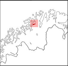
Moll Exploration controls a highly prospective land position at Láhku within the Repparfjord District, Finnmark County, northern Norway. The property (Licence No. 060/2026) comprises six exploration licences covering a total area of 60.14 km².
The licences cover part of the Repparfjord tectonic window, where Early Paleoproterozoic volcano-sedimentary sequences are exposed at surface within the Fennoscandian Shield.

These rocks display strong geological similarities—in host-rock assemblage, sedimentary textures, and sulphide mineralogy—to globally significant sediment-hosted copper systems such as the Central African Copperbelt and the Kupferschiefer of Central Europe. Regional prospectivity for copper and silver is clearly demonstrated by the nearby Nussir mine and Ulveryggen deposits, which together contain more than 60 million tonnes grading approximately 1.01% Cu and 15 g/t Ag. These deposits occur along strike of Moll Exploration’s Lahku project within the same favourable stratigraphic corridor, reinforcing the exploration potential of the Company’s ground.

Moll Exploration’s licences cover the southwestern extensions of the Nussir–Ulveryggen sediment-hosted copper-silver mineral system, where mineralisation is hosted within siltstone–dolostone–slate sequences of the Gorahatjohka Formation. The district exhibits a pronounced tectonic overprint, expressed through regional and local shear zones and penetrative foliation fabrics. This structural reworking may have remobilised and locally upgraded primary diagenetic mineralisation into structurally focused, epigenetic zones of enrichment—effectively enhancing the scale potential both laterally along strike and vertically at depth. Despite the presence of established resources nearby, the Láhku area itself remains underexplored by modern, systematic exploration methods.

Moll Exploration’s strategy is to unlock this potential through disciplined, data-driven field programs. Planned work includes high-resolution geological mapping, systematic rock and soil geochemical sampling, and rigorous structural analysis to refine targeting.
Complementing this groundwork, the Company will deploy its geophysical technology capable of imaging disseminated to massive sulphide-rich subsurface features to depths of approximately 250 metres. In addition, an extensive electrical geophysical survey programme will be conducted. In an initial phase, resistivity profiles to depths of up to approximately 250 metres and induced polarisation (IP) models to depths of around 70 metres will be acquired over large areas using a lightweight, high-productivity survey system capable of achieving high daily line-metre coverage.
By integrating detailed surface data with advanced geophysics, Moll Exploration aims to materially increase targeting precision and maximise the probability of discovery within this proven copper-silver belt.
Geosciences Academy Exploration Project
The Geosciences Academy Exploration Project is an industrial-led and commercially driven mineral exploration programme conducted by Moll Exploration, integrating a supervised, geoscience-focused student research group that works alongside ongoing industrial field operations.
Moll Exploration has secured a strategic land position in the Karasjok area of northern Finnmark, Norway. The property (Licence No. 0381/2026) covers a total area of 58.88 km².

The region has a long history of small-scale artisanal placer gold production and lies within the Karasjok Greenstone Belt—a Palaeoproterozoic volcanic–sedimentary terrane extending southwest into Finnish Lapland and considered analogous to other gold-fertile greenstone belts across Fennoscandia. Placer gold discoveries in rivers and gravels during the 19th century, including documented nuggets near Karasjok village and surrounding streams, triggered early alluvial mining and prospecting activity.

Geologically, the belt comprises a rift-related sequence of mafic and felsic volcanic rocks interlayered with sedimentary units—a setting known elsewhere to host orogenic gold and associated base-metal mineralisation. Although coarse alluvial gold is still reported in local gravels and various explorers have held licences over time, there is currently no operating gold mine in the area.
Limited bedrock exploration during the 20th century, including work by the Geological Survey of Norway and several companies, identified sulphide-rich horizons such as the Raitevarri Cu–Au occurrence, where minor gold and base metals occur in metamorphosed gneisses and schists. Historical placer investigations at nearby Storfossen reportedly recovered approximately 5 kg of gold from sediments within the wider exploration area at grades of approximately 0.8–0.9 g/m³. Both localities lie within Moll Exploration’s broader licence position. Further south, at Sargejok, approximately 10 km from Karasjok, historical prospecting reportedly produced around 20 kg of gold, with recoveries estimated at between 2.2 and 2.59 ounces of gold per man per day.

To date, exploration across the wider area south of Karasjok has been confined to a limited number of small, localised targets. As a result, the region remains largely underexplored and represents a frontier for systematic modern exploration. The greenstone belt is considered prospective for orogenic and related gold systems, where detailed geological mapping, geochemical surveys, and modern geophysical methods may help vector toward primary bedrock sources of mineralisation.

Moll Exploration intends to advance the project through a data-driven, field-focused approach, working in close communication and cooperation with local communities. Planned fieldwork will be conducted with low environmental impact and will utilise the company’s in-house geophysical survey tools to identify subsurface structures and potential primary gold sources.
Scientific and Educational Integration
The exploration project is concurrently designed as a long-term scientific and educational initiative. Field activities are carried out by Moll Exploration’s professional exploration team. The geological, geochemical and geophysical data collected form the foundation for academic work within the Geosciences Academy programme.
The Academy is conducted in cooperation with Einstein-Gymnasium in Germany, where a supervised geoscience working group analyses current exploration data as part of an advanced extracurricular research programme. Within this framework, students evaluate samples and datasets, review exploration strategies, and develop conceptual models aimed at identifying potential, as yet undiscovered primary gold mineralisation in the bedrock.

Geosciences Academy student research group conducting supervised geoelectrical field measurements in Germany
Through this structured integration, the project combines industrial mineral exploration with applied geoscience education, providing students with direct insight into modern exploration methods under professional supervision.

https://www.einstein-kehl.de/de/05-freiraeume/ags.php
Scroll down and click „Geosciences Academy“

Under the guidance of Philipp Moll, students from the Einstein Gymnasium in Kehl, Germany, conducted an IP mapping survey on the site of a former Germanic settlement dating back to around 300 AD. By 2009, only limited traces of the original village layout could be reconstructed, as mechanical farming had largely destroyed the subsurface structures. However, the students managed to collect numerous archaeological artifacts!
Archeology
Scientific
Selection of Reports:
Haggart
https://yma.gov.yk.ca/120270/120270.pdf
https://yma.gov.yk.ca/120271/120271.pdf
Pine
https://apps.nrs.gov.bc.ca/pub/aris/Report/33342.pdf/
https://apps.nrs.gov.bc.ca/pub/aris/Report/32412.pdf/
Diamond Tooth
https://yma.gov.yk.ca/120326/120326.pdf
51 Pub
https://yma.gov.yk.ca/120218/120218.pdf

From 2006 to 2020, Philipp conducted numerous geoelectrical surveys for both placer and hardrock mining operations in Yukon/British Columbia and Alaska. Working closely with clients and experts from other service companies, he played a key role in the success of many mining operations.
Contract Work for Industry

In 2010, Philipp led a 45-day geophysical survey for the Canadian government. Four remote wilderness areas in the Yukon Territory were investigated using 2D Resistivity and IP methods, covering a total of 10,975 line meters. The objective was to identify new targets for potential placer and shallow rock mining opportunities.
Philipp Moll, Arctic Geophysics Inc. Canada
Contract Work for Government
History